The Impetus for Evidence-Based Planning (EBP)
As many cities grow and evolve, so do the elements of the urban planning process that are used to incept, design, and build it. In today’s evolving world, urban planning calls for the anticipation of natural crises and technological breakthroughs, which in turn require urban plans to be resilient and flexible.
The pandemic and global awareness of climate change has significantly shifted our perception of how our living environment should be like. New concepts such as the 15-minute city, Blue Zone, and Active city have become increasingly popular, and urban development products such as evidence-based planning (EBP) tools have been consistently transforming to provide relevant urban planning data. EBP tools and their ability to glean meaningful insights from urban data is hence, a necessity for sound planning that will improve a city’s metabolism, strengthen its resilience and allow it to anticipate and respond to future needs.
More significantly, master developers and cities are recognising that a cookie cutter approach will neither be sustainable nor resilient in the long-term. EBP tools enable urban planners to gather data and evidence to generate new planning ideas and directions that would be specifically applicable and relevant to a development’s unique requirements. In the first of this series, we will be sharing case studies of successful masterplans that have incorporated valuable insights gained from our EBP approach.
Evidence as Ammunition to Hit Planning Targets
At CPG, our Urban Planning team has long been using EBP to enhance our planning processes. EBP facilitates decision-making in the early stages of the planning process by providing insights derived from urban data, which highly increases efficiency and prudency. This in turn, enables us to mitigate development threats and risks, while ensuring that our clients are able to validate their project positioning and achieve the unique requirements of their developments.
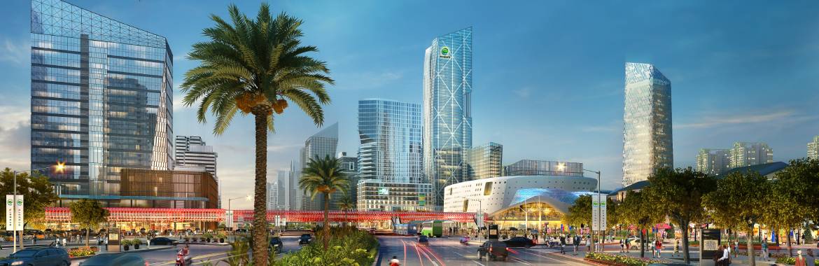
For instance, two city projects in Vietnam undertaken by the Urban Planning team were developed using EBP tools, with a focus on conceptualisation and design validation. The projects in Hung Yen Province, Da Nang City and Nha Trang City, addressed the themes of nature, adoption of digital twin technology and wellness development.
The Nha Trang Master Plan leveraged EBP tools such as spatial syntax analysis and customised spatial analysis and modelling toolkits in the early design stages to help gauge efficient ways of maximising space for optimal economic performance. Such data was particularly useful for a project like this which is related to the tourism sector.
Guided by data, the alignment of the road structures and resulting accessibility also enabled the development to be more connected to the Central Business District (CBD). By being more accessible to the CBD, it is estimated that the attraction force capacity (increased visitor traffic as a catalyst for economic activity) will result in an improvement of 21% more visitors, as compared to other master plan designs proposed. Through the synergic effects that resulted from the judicious allocation of certain spaces, up to 20 hectares of premium plots which would otherwise be wasted, were also freed up for use.

Comparison of two options of Nha Trang Master Plan
The projected vehicular flow and its effect on visual exposure and accessibility were used to determine the locations of business spaces, public institutions and large commercial land. Similarly, the projected footfall was used to co-locate the commercial and recreational land areas, considering the positive effect of high pedestrian traffic on business performance. These approaches have helped to identify premium plots with increased land value of about 10-15%.
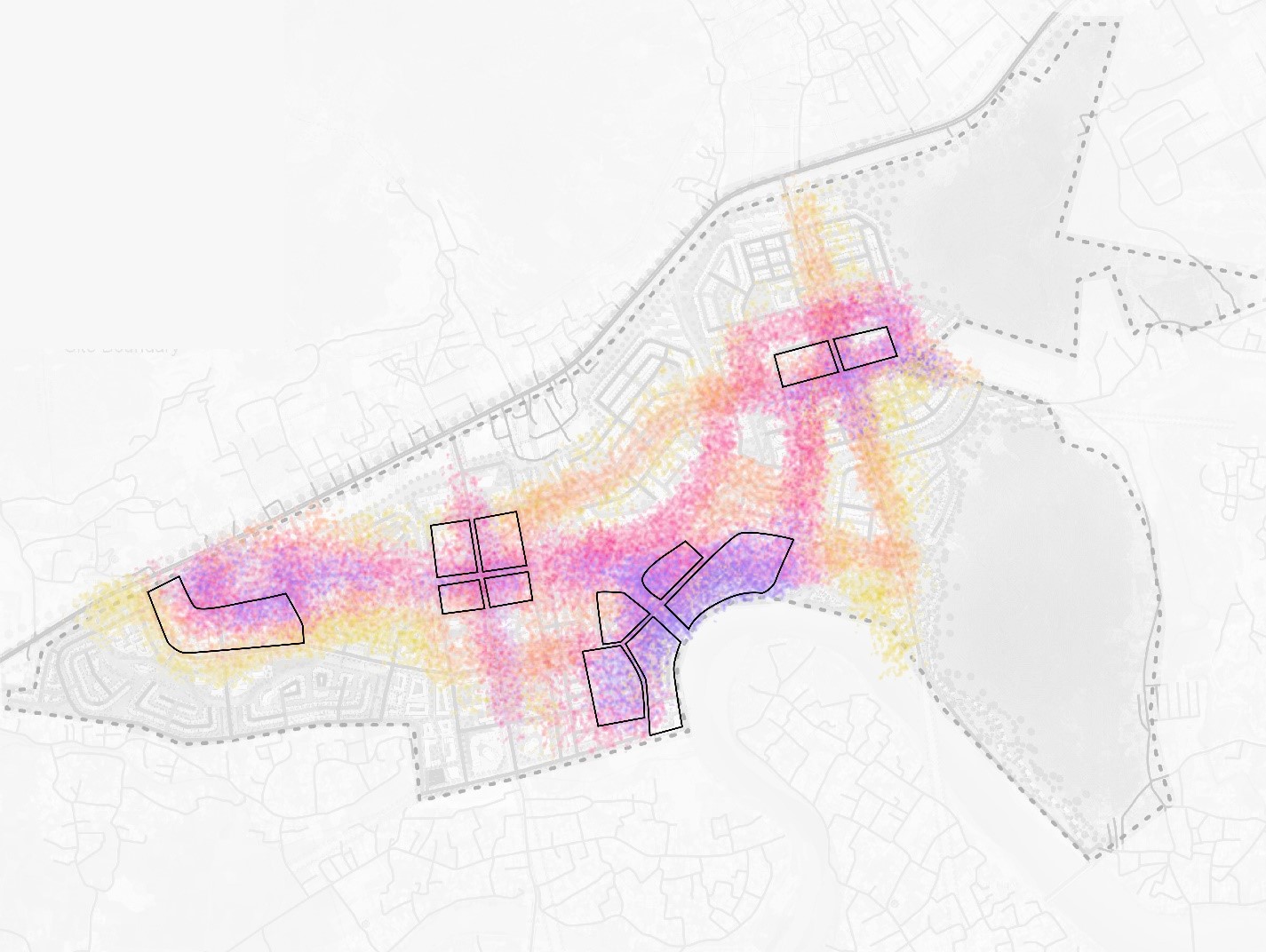
Allocation of commercial plots considering the pedestrian footfall along the park connectors and streets in Nha Trang Master Pla
By using EBP tools and gaining valuable insights from the data, we were able to advise the client on ways to unlock and maximise space, which makes for a more strategic urban plan that is in line with the client’s business objectives.
In another project, the Imex Pan Pacific Group (IPPG) Smart City Master Plan, EBP methods are being adopted by the CPG Urban Planning team to validate and measure key performance indicators. We produced an evaluation matrix that assesses a city’s liveability, economic competitiveness, and smart city certifications. These factors are especially crucial for any city in the age of endemic living. As planning for an even longer term and on a bigger scheme of things, we are also assisting the master developer in obtaining the “ISO 37106”, which gives guidance for leaders in smart cities and communities (from the public, private and voluntary sectors) on how to develop an open, collaborative, citizen-centric and digitally-enabled operating model for their city that puts its vision for a sustainable future into operation. With the setting up of such a matrix, it is hoped that it can be further developed as the standard smart city guideline for the rest of Da Nang City.
Combining Data with Concept
An example of combining planning concepts with the use of data which was explored by the CPG Urban Planning team, is the area of recreational green distribution. In conventional planning methods, the master plan aims to achieve the green per capita standards at the macro level, without much consideration for the actual practical usage of such green spaces.
In this case, measures were devised to define the performance of parks in maximising value. Through EBP tools, we determined that purposeful small green parks are more successful in attracting visitors and generating activity, as compared to large green areas. Using planning parameters and scoring land synergies, pedestrian traffic and major public open spaced location, we derived a heat map showing accessibility and purposefulness of the green areas. This understanding then enabled our team to optimise the size of green spaces and curate models for maintenance and upkeep.
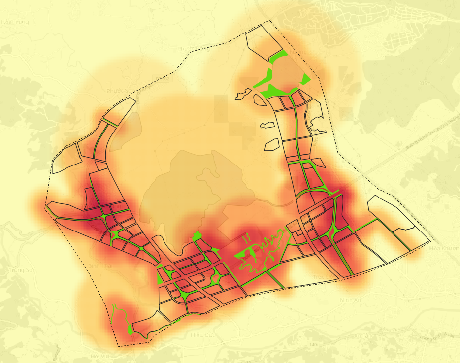
IPPG Smart City Park Layout showing the park network, with the shaded areas indicating higher efficiency
Increasingly, more importance and higher expectations are placed on the availability and accessibility of green spaces in urban city planning, as such spaces have been proven to reduce the stress of urban and infrastructure environments; and create greater opportunities for the community to interact and enrich themselves.
Driving the Future with EBP
Moving forward, it is likely that urban planners will increasingly use EBP methodology to make the best and most informed design and planning decisions. The pressing need to address the impact of climate change has also required EBP tools to evolve. Now, data on heat island effects, walkability and micro-climate in urban design helps us conceive methods to reduce carbon emissions and improve comfort through active cooling methods and other means, which will be covered in the next article of this series.
By collaborating closely with universities, government agencies, technology and urban solution partners, our Urban Planning team is constantly refining our approach and the use of EBP tools through data sharing, application development and urban development playbooks. With numerous layers in urban planning such as transportation, public open spaces and land allocation, there are always new assumptions that arise in response to changing global conditions such as technological changes and global crises (e.g. climate change and the pandemic), it is only through the continuous exploration and utilisation of new knowledge and sciences that we are able to not just create practical physical master plans, but also elevate our planning consultancy to the next level.
This article was authored by:
Rodeo Cruzado, Senior Principal Urban Designer
Urban Planning Division
rodeo.cruzado@cpgcorp.com.sg
Namita Paul, Urban Designer
Urban Planning Division
namita.paul@cpgcorp.com.sg